
What Google Maps Shows You About Lighthouse Point, Florida
Quick Answer: Where is Lighthouse Point on Google Maps?
| Detail | Information |
|---|---|
| Location | Northeastern Broward County, Florida |
| Coordinates | 26.27564° N, 80.08727° W |
| ZIP Code | 33064 |
| Elevation | 3.3 ft above sea level |
| Bordered by | Deerfield Beach (north), Pompano Beach (south/west) |
| Total Area | ~2.4 sq miles (approx. 1,600 acres) |
Google Maps Lighthouse Point gives you an immediate aerial view of one of South Florida’s most distinctive waterfront communities — a compact, nearly fully developed city tucked into the northeastern corner of Broward County.
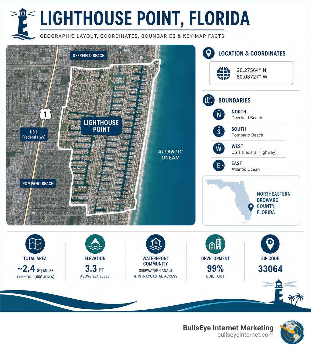
At first glance, the satellite view tells the whole story. You see a tight grid of residential streets laced with deepwater canals, bordered by the Atlantic coast to the east and US 1 (Federal Highway) to the west. It’s a city that is 99% built out, with almost no vacant land remaining.
That density makes it surprisingly easy to navigate — but only if you know what you’re looking at.
This guide walks you through exactly what Google Maps reveals about Lighthouse Point: its boundaries, waterways, landmarks, and how to pull precise coordinates and addresses for any location in the city.
I’m Ronnie Katz, founder of BullsEye Internet Marketing, and since 2006 I’ve helped businesses across South Florida — including in communities like Google Maps Lighthouse Point — improve their local map visibility and turn online searches into real phone calls. In this guide, I’ll share what the maps actually show you and how to make the most of that information.
Google Maps Lighthouse Point terms explained:
Navigating Broward County with Google Maps Lighthouse Point
When you zoom into the northeastern region of Broward County on a digital map, Lighthouse Point stands out as a masterclass in coastal suburban planning. Covering approximately 1,600 acres, this highly desirable enclave is bounded by the city of Deerfield Beach to the north and Pompano Beach to the south and west.
Using the Lighthouse Point Map, Satellite view of Lighthouse Point, FL, USA, you can clearly trace the city’s western boundary, which is defined by US 1 (Federal Highway). The eastern edge is bordered by the Intracoastal Waterway, providing direct deepwater access to the Atlantic Ocean.
Because the city is 99% built-out, there is virtually no vacant land left to explore. As of the latest municipal records, only a handful of vacant single-family and multi-family lots remain. This means the street grids, commercial plazas, and residential canals you see on Apple Maps or Google Maps are highly stable, representing a mature, fully developed community.
How to Use Google Maps Lighthouse Point for Coordinates and Elevation
If you need to find precise location details, Google Maps Lighthouse Point makes it incredibly simple to pinpoint any exact spot. Whether you are mapping out a real estate property, planning a boating trip, or setting up a local service route, coordinates and elevation data are just a click away.
To find the coordinates of any location:
- Open Google Maps on your computer or mobile device.
- Right-click (or long-press on mobile) on your desired location in Lighthouse Point.
- A pop-up window will appear at the bottom of the screen showing the decimal latitude and longitude.
- For reference, the general coordinates for the center of the city are latitude 26.27564 and longitude -80.08727.
At an average elevation of just 3.3 feet above sea level, the entire city is low-lying, which is typical for coastal South Florida. The primary ZIP code serving this area is 33064. If you are sharing a specific map location with clients or partners, you can easily learn How to Find Google Maps URL to send clean, direct links to any address in the area.
Transportation Routes and Access Points
Lighthouse Point’s transportation network is designed to keep regional traffic moving smoothly along its perimeter while preserving the quiet, residential nature of the interior neighborhoods.
The primary artery defining access to the city is US 1 (Federal Highway), a 6-lane divided arterial road that handles an average capacity of 49,200 vehicles per day. This serves as the bustling commercial western boundary of the city. Major east-west access is provided by Sample Road (NE 36th Street) and NE 49th Street, both of which connect Federal Highway to the interior residential areas.
According to the official City Map | Lighthouse Point, FL, navigating within the city limits is incredibly straightforward. The city features exactly 10 signalized intersections to manage traffic flow. Best of all for drivers, there are no drawbridges or railroad crossings within the city limits, meaning you won’t experience the sudden traffic delays common in neighboring coastal South Florida cities.
Residential Layout and Street View Insights
When you drag the Google Street View “pegman” onto the residential streets of Lighthouse Point, you immediately see why this city is highly coveted. Residential land use dominates the city, accounting for approximately 84% of the total 1,600 acres.
According to historical census data, the city contains approximately 5,871 total housing units, with single-family homes making up about 74% of the residential footprint. The median home value here has historically sat well over 95% higher than the Broward County average, reflecting the premium placed on this waterfront community.
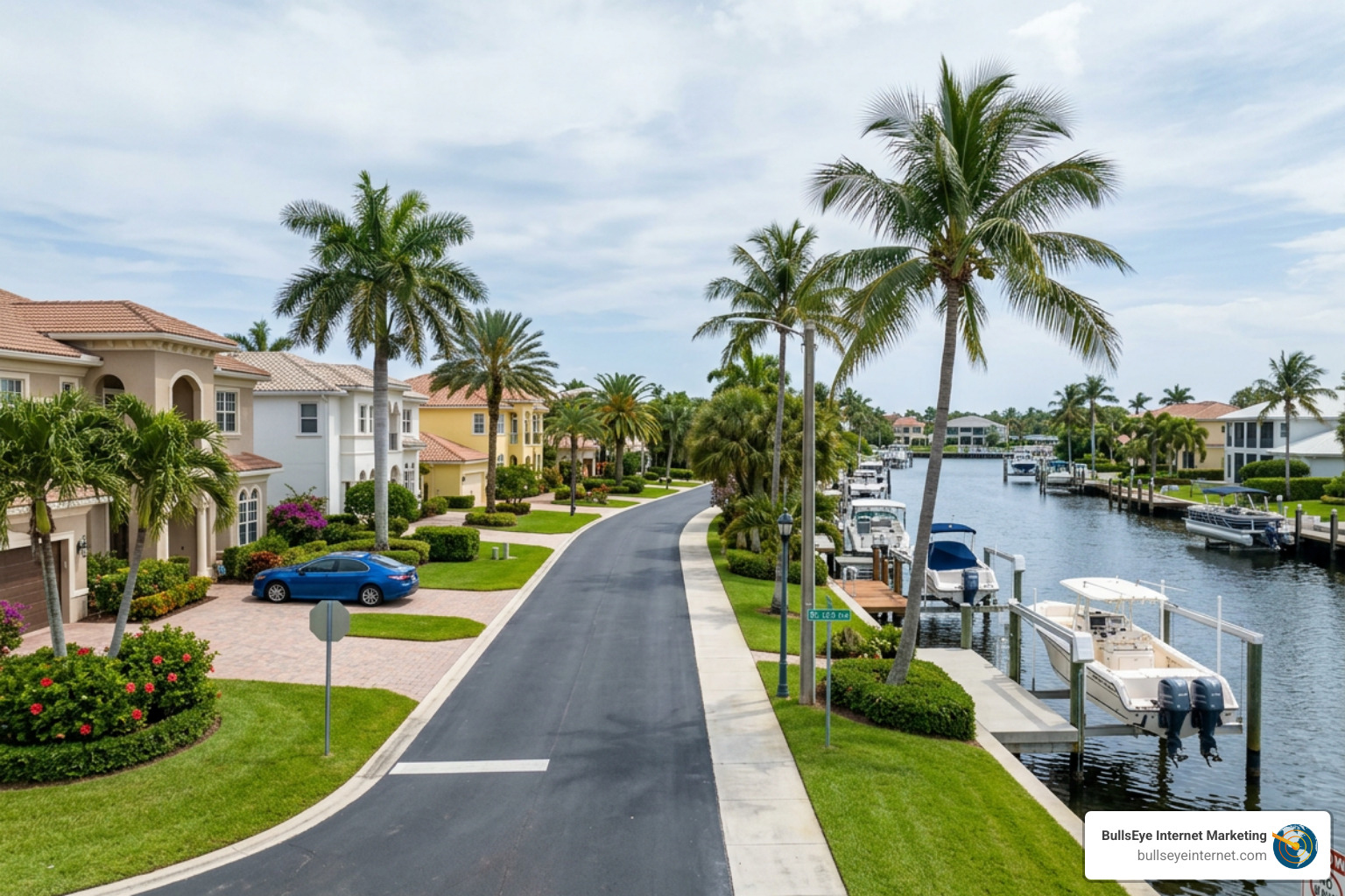
As you virtually stroll through neighborhoods like Venetian Isles or Coral Key using Street View, you will notice a mix of classic mid-century Florida ranch homes and sprawling, multi-story modern estates. If you are a local business owner looking to reach these high-income households, establishing a strong local search presence is essential. Utilizing customized SEO Lighthouse Point strategies can help your business show up directly on the maps when residents search for local services.
Exploring Waterways and Canals via Google Maps Lighthouse Point
The defining characteristic of Lighthouse Point is its spectacular canal system. The city boasts approximately 33 miles of residential frontage along deepwater canals and waterways.
If you switch your map view to satellite imagery on Lighthouse Point, FL, United States – Map & Directions – Apple Maps, you will see that over 50% of all single-family lots have direct access to the city’s waterway system. These wide, deep canals connect directly to the Intracoastal Waterway, allowing residents to dock large boats and yachts right in their backyards. Because there are no fixed bridges blocking access to the ocean from most of these canals, it is a true paradise for boaters, which is easily visible when zooming in on the docks and vessels lined up along the water.
Landmarks, Parks, and Points of Interest
While Lighthouse Point is primarily a quiet residential community, it is home to several unique landmarks and points of interest that are fun to explore on Google Maps.
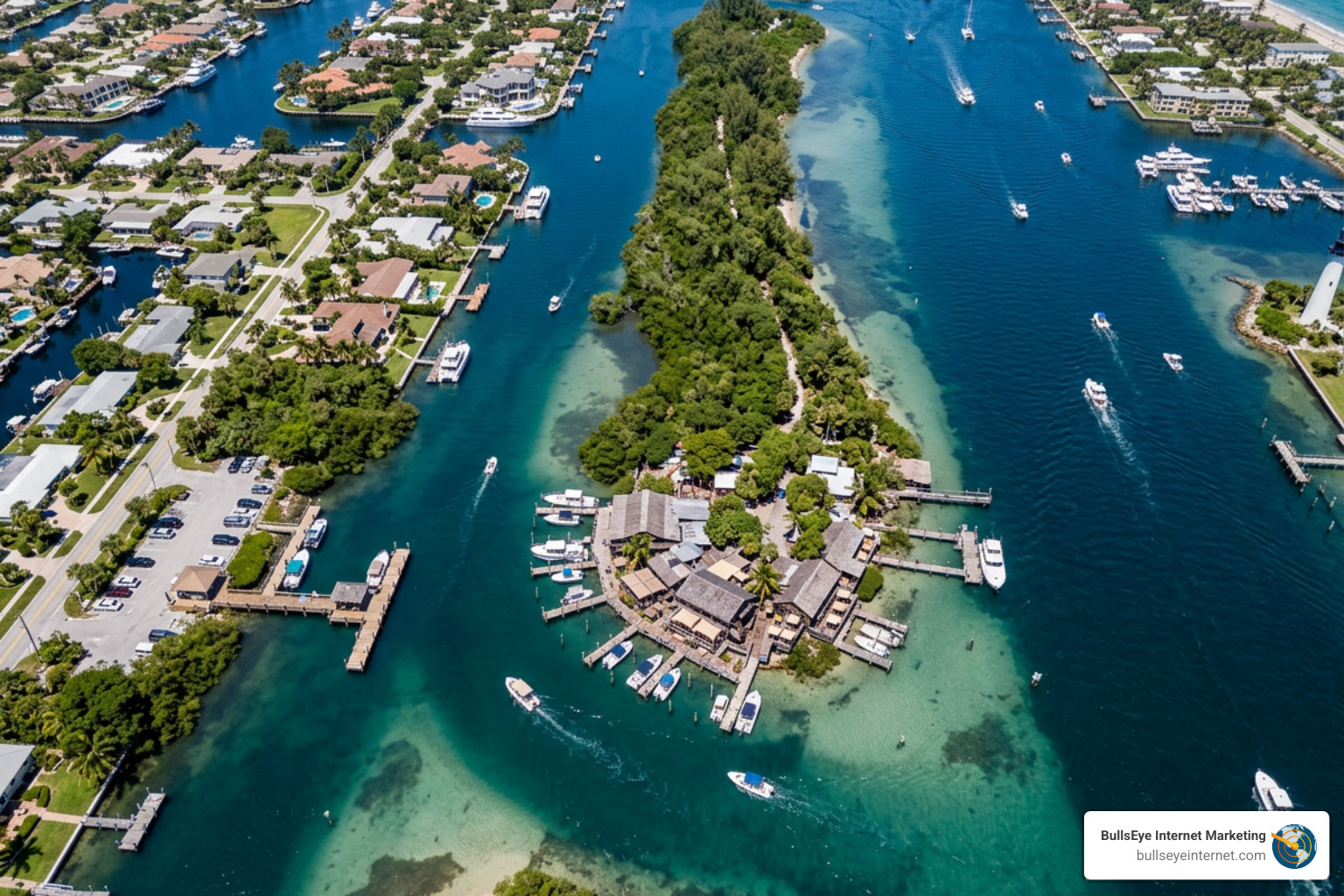
The most famous historical landmark in the area is Cap’s Place. Built in 1929 and listed on the National Register of Historic Places, this historic restaurant has operated continuously for nearly a century. It famously hosted prominent political figures and celebrities during World War II. Because it is located on a shallow peninsula near the Hillsboro Inlet, it is not accessible by traditional roads; visitors must take a short water taxi ride from the mainland dock in Lighthouse Point to reach it.
You can easily locate the mainland dock and the restaurant itself on the Lighthouse Point, FL | Official Website or by searching directly on Google Maps.
Parks, Marinas, and Community Facilities
Lighthouse Point features several beautifully maintained parks, marinas, and community facilities that are highly visible on digital maps:
| Facility Name | Type | Key Features Visible on Maps |
|---|---|---|
| Dan Witt Park | Community Park | Athletic fields, tennis courts, playground, community center |
| Frank McDonough Park | Community Park | Tennis center, playground, athletic fields, close to the library |
| Lighthouse Point Yacht Club | Private Club & Marina | Marina slips, tennis courts, pool, waterfront dining |
| DeGroff Park | Passive Park | Waterfront views, walking paths along the Intracoastal |
For businesses operating near these high-traffic community hubs, being visible to visitors is a major advantage. If you want to make sure your local business is the first one residents and visitors see when they search the area, check out our Local SEO Complete Guide to learn how to optimize your map listings.
Frequently Asked Questions about Lighthouse Point Navigation
Navigating a unique, canal-heavy city like Lighthouse Point often brings up specific questions. Below are some of the most common navigation and mapping queries answered. If you are a business owner looking to master how your location appears in these types of local searches, our guide on Beyond the Pin: Mastering Local SEO for Google Maps Visibility offers deep insights into optimizing your digital footprint.
Where is Lighthouse Point located in Florida?
Lighthouse Point is located in the northeastern corner of Broward County in South Florida. Its boundaries are defined by Deerfield Beach to the north, Pompano Beach to the south and west, and the Intracoastal Waterway to the east. It sits just west of the famous Hillsboro Lighthouse.
Can you see Cap’s Place on Google Street View?
Because Cap’s Place is located on a secluded peninsula surrounded by water, you cannot view the restaurant itself via standard Google Street View. However, you can view the mainland water taxi dock on Street View at the end of NE 29th Street, and you can explore the restaurant itself using satellite imagery and user-uploaded 360-degree photos on Google Maps.
How many canals does Lighthouse Point have?
While the exact number of individual canal branches varies, the city features an incredible 33 miles of residential canal frontage. Over half of all single-family homes in the city sit directly on these deepwater canals, offering unobstructed access to the Intracoastal Waterway and the Atlantic Ocean.
Conclusion
Whether you are a resident mapping out a weekend boat route, a visitor looking for a historic dining experience, or a local business owner trying to connect with the community, Google Maps Lighthouse Point is an invaluable navigation tool. In June 2026, mapping accuracy and local search visibility are more critical than ever for local businesses looking to thrive in this high-income coastal market.
At BullsEye Internet Marketing, we specialize in helping local businesses dominate search results and map listings. We offer tailored digital marketing services with no long-term contracts, and we work with only one client per industry per geographic area to give you a true competitive advantage.
Ready to put your business on the map? Let us help you optimize your local presence. Explore our expert guide on Business Listing Optimization and contact us today to get started!
